


The seven member Gorham Conservation Commission (GCC) recently held a public meeting to gather input from the public regarding three possible options for an expansion of the Cross Town Trail (CTT).
The 1.5 mile CTT currently runs adjacent to New Portland Road, along the bed of the former York and Cumberland Railroad and ends at Hutcherson Drive in the Industrial Park. The track was removed in the mid-20th century. Limited parking is available across the street from Lake Region Oil Company. The CTT can also be accessed by walking through the Meadowland Preserve, at the end of Joseph Drive.
All three of the proposed new options would extend the range of the CTT by providing access from the Village down to Mosher’s Corner and the junction Main Street and Rt. 237 near Martin’s Point, Beals Ice Cream, and several other commercial businesses.
This expansion would allow the CTT to take advantage of a future project by the State which will construct a pedestrian walkway connecting the Beals Ice Cream side of Rt. 25 to the Cherry Hill side with it’s system of walking and biking trails.
The planning process included the design of a detailed matrix of qualifying factors with each spur option being given a score in areas such as scenic/natural environment; ownership/property rights; connection to businesses; elevation change; impact/disruption to wetlands; how direct is the route; and relative cost.
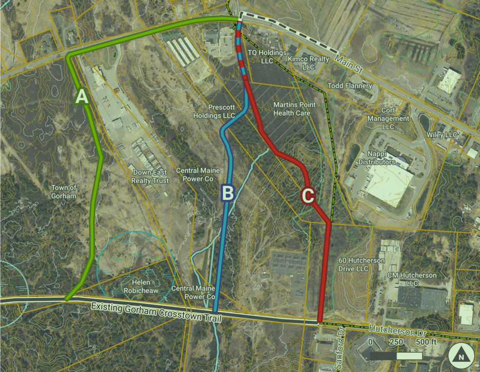 Photo credit: Gorham Conservation Commission
Three options are being considered to extend the Gorham Cross Town Trail from the Village down to Mosher’s Corner.
Option A crosses town-owned land from New Portland Road over to Rt. 25. It connects closer to the Village which means that a long portion of the trail would run adjacent to the right-hand side of Main Street, down to the Mosher Road intersection. This is the most expensive and least scenic of the three but has the benefit of using land which the town owns.
Option B and C would connect closer to the end of the current segment near the Industrial Park. Segment B had the highest score on the qualification matrix but will require working with CMP to gain approval to cross their land near a transmission line. Option C crosses 2 private parcels of land, traveling through land owned by Martin’s Point on which the town already has an easement. Both parcels B and C are more scenic but they cross a large wetlands (C has more wetlands) which would add to the cost of the project.
Next steps in the planning process include determining if CMP will work with the town on Option B access rights as they have done with other communities in the Greater Portland area.
Funding sources are also being explored including grants and Federal funds, monies from the Greater Portland Council of Governments, and Land for Maine’s Future.
After the presentation, a number of community members made comments and asked questions. Everyone spoke favorably in support of the project and expressed excitement about the increased recreational opportunities it will provide community members.
GCC trails are open year round. Their trails include Tannery Brook, Clair Drew and Frasier & Weeks Road. There is no ATV access; Carry In, Carry Out; No Camping.
Maps are available to download to your phone on the GCC FB page. GCC is always in need of volunteers to help keep the trails in good conditions for the community to enjoy.
The GCC’s goal is to increase trail connectivity, encourage outdoor activity, reduce polluting emissions, and provide access to the natural environment. Its purpose is to care for and supervise Gorham’s public parks. The Commission is chartered by State Law Title 30A and is subject to the approval of the Town Council.